


Heavy Rain Could Trigger Flash Flooding Across the Central U.S.
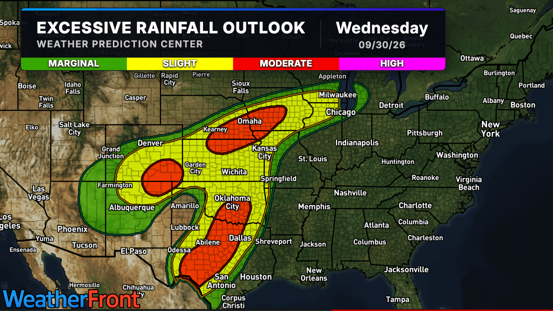
A widespread heavy rain event is taking shape across portions of the Southern and Central Plains into the Corn Belt, bringing an increasing risk of flash flooding through early Thursday.
A Moderate Risk for excessive rainfall is in place for multiple areas, with some locations potentially picking up several inches of rain in a short period of time.
Texas and Oklahoma Face Heavy Rain
Thunderstorms are expected to become more widespread across the Southern Plains as a cold front moves through Texas and Oklahoma.
A very moist and unstable atmosphere could support thunderstorms capable of producing significant rainfall. There is a strong signal for more than 3 inches of rain from portions of southwest and central Texas into the Red River Valley, with some locations potentially receiving more than 5 inches.
Repeated thunderstorms could increase the risk of flash flooding, especially Wednesday evening and overnight.
Flood Threat Extends Into the Corn Belt
Farther north, heavy rain is expected from northern Kansas and southern Nebraska into Iowa.
Thunderstorms could repeatedly move over some of the same areas, producing rainfall rates of 1–2 inches per hour at times. Widespread totals of 2–4 inches are possible, with localized amounts potentially reaching 6 inches.
The corridor from near the Kansas-Nebraska border through Omaha and toward Des Moines, particularly areas along and south of Interstate 80, could face an elevated flash flood threat Wednesday night.
More Rain for the Southern Rockies
Southern Colorado and northern New Mexico could also see another round of heavy precipitation.
An additional 2–4 inches of rain, with locally higher amounts, could fall across portions of the Southern Rockies and Front Range. Recent rainfall has already left soils wet in some locations, meaning additional heavy rain could more easily lead to flash flooding.
Stay Weather Aware
Heavy rain can quickly make roads dangerous, especially at night when flooding can be difficult to see.
Never attempt to drive through a flooded roadway. Water may be deeper than it appears, and the road underneath could be damaged or completely washed away.
Keep an eye on your local WeatherBug alerts and forecast as storms develop through early Thursday.